 |
Rob MacLeod and Dan Mayhew 1
This document describes a suggested sign standard for the Bonneville Shoreline Trail (BST), and by extension, any trail system with similar goals. This manual, as with all design standards adopted for the BST, are not meant to prescribe what must be done, but only to suggest what can be done. We wish only to spare other groups the effort that we have expended developing signage standards and hope that they find our experiences of use. We encourage feedback and news of how these ideas work for other and request that you share with us your own experience. The authors can be reached by way of the Salt Lake City Mayor's Bicycle Advisory Committee, Mayor's Office, 451 South State Street, Salt Lake City, Utah 84111, by phone: Rob Macleod: 801 583-2855, or via email at macleod@cvrti.utah.edu.
The organization of this guide is to first describe the different types of trail segments to which we wished to apply signage; this forms one hierarchy of the recommendations. We then illustrate the different forms of signs that we have developed and indicate where they are to be used. A special section is dedicated to the logo sign, a component of the system that, more than any other, defines the look and feel of a trail system. Here too, we have developed a hierarchy within the logo sign itself -- one that we hope will strike a balance between useful uniformity and the beauty of the imagination that lies behind every trail that every gets built.
Please note: this guide is a document under construction and as such, contains errors, omissions and probably a few outright lies. Please be tolerant and helpful in improving this document.
...Trails are about our links to the land; signs just help us to find them.
The Bonneville Shoreline Trail is an urban fringe trail system that will eventually wind its way along the entire ``bench'' area of the Wasatch Front. The benches originated as the shorelines of the prehistoric Bonneville Lake, the remnant of which formed the Great Sake Lake and Utah Lake. The steepness of the grade above and below the benches has restricted some development, while in other places the benches have either been built upon, or had access to them blocked by private homes. As a result, any trail which is to encompass the entire Wasatch Front must be a compromise between true off-road paths and more developed alternatives. As an urban fringe trail system, it is also crucial to offer well designed, controlled access points to the BST, and to provide clear markings of these trailheads and the course of the trail system itself.
We have developed three levels of signage standard, each for a different spot in the trail system. The three components of the sign hierarchy correspond to a) urban trails that are on existing roadways (eg., Class III bike routes), b) the off-road trails that make up the bulk of the BST system, and c) the trailhead access points and points of intersection between the urban roadways and off-road trails.
Urban trail segments should make use of existing signposts and locations and simply augment existing sign standards (described by entities such as AASHTO or local jurisdictions). The goal is to guide a trail users along the roadway, reassure them that they are, indeed, still on a trail, and provide directions to trail access points as they arise.
The standard we suggest for such urban trail segments is a rectangular panel that can be attached to existing road-sign posts. The panel could contain a logo for the trail to which the road segment belongs, along with directions, in textual form and/or direction arrows to lead users along the trail and to trailhead access points. The ideal location for such signage is adjacent to the signs that otherwise mark the route as, for example, a bicycle route. The notion behind basing these signs on a logo is to promote quick recognition and establish a link to the off-road trail system, which we anticipate will be the primary destination of most trail users. We anticipate using the same sign design for this purpose as for the inserts in the sign posts described in section 2.3.
As for the color of these signs, the brown and white suggested below for the trail signs might enhance recognition of the signs as marking something more than just another bike trail or roadway.
One example of such signage is along Wastch Blvd. and Devonshire Dr. in Salt Lake City where the BST runs along the roadway in a Class III route for several miles.
We have been encouraged by offers from both the Forest Service and the City of Salt Lake Dept. of Transportation to assist us in developing and fabricating these signs. Salt Lake City has provided assistance with sign design and fabrication for the road segment of the trail mentioned above.
On the off-road trails themselves, we have adopted a sign standard similar to that presently used by the Forest Service. This uses a fiberglass flexible dual sided trail marker manufactured by Carsonite.
The content of these signs should be informational and include some of the following:
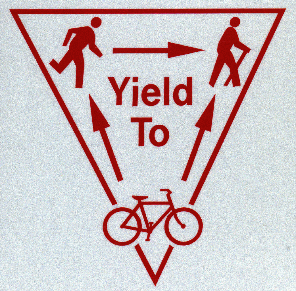
We have implemented the content of the signs in the form of decals that stick on the trail markers. We have several basic sticker designs (eg., Figure 1) and can provide local Bonneville Shoreline Trail organization with such stickers.
|
|
The source of the trail markers is Carsonite International Corp: (800)
648-7915,
The marker signs cost about $15.00 per unit and there is an additional ``curv-flex anchor'' which they will attach to the posts for an additional $1.50. Be sure when ordering signs to all purchase the post driver tool (D400R) and the pilot hole driver (DP100), each of whihc costs about $100.
A separate type of signage is required to marks points of interface between urban/developed roadways and the trail proper. This can occur at a designated trailhead, but also where the trail crosses a roadway or interacts in any way with developed areas. The purpose of these signs is to indicate the required change in traffic, and hence behavior required of trail users. For this we have chosen perhaps the most impressive (and most expensive) type of signs, a reflection of the importance we place on the need to ``switch gears'' when entering or leaving a trail section.
The physical form of these signs should be large and contain space for
several different individual signs or messages. We have chosen as a model
the trailposts used by the Wood River trail system in Blaine County, Idaho.
The signposts are made from either massive or laminated wood with a cross
section of 12 by 6 inches and a length of from 5 to 7 feet. Each wide side
of the post has up to three, 8 x
The insert signs we have used so far, created by the Salt Lake City,
Department of Transportation sign shop are 7
The signs that make up the inserts have many functions and must carry many
messages in as clear and simple a way as possible. Examples of the insert
signs are show in the figures below. Their purpose is to achieve some of
the following:
As of April, 2000 there are over 20 signs of this type in place, most with
inserts that Salt Lake City has generously fabricated for us. We will soon
have plans for these inserts so that private sign shops can also make
them. The posts have weathered very well and also have suffered little or
no vandalism. These signs are all located along the Steiner Centennial
section of the BST that runs from Emmigration Canyon to City Creek.
Obtaining materials for signposts of this type has proven to be rather
difficult as the size required does not conform to timber used in standard
construction. We have, however, been able to develop a local source of
both the raw material and the manufacturing of the signs in Mr. Wayne Hall,
1335 South 900 East, Salt Lake City, UTAH 84105 (tel: (801) 486-6030 ).
The present cost of each post is approximately $200.
The logo sign was developed with the assistance of Mr. B.J. Nichols and
incorporates elements of the urban Wasatch Front, the historic Bonneville
Lake, and the mountains of the area. This too has a hierarchal structure
with a) the color scheme and general layout as the base layer, on top of
which we add b) the specific logo, to which we further add c) any textual
information. The hierarchy can be pictured as follows:
Please note that the Bonneville Shoreline Trail logo
(Figure 2) is copyrighted by the Bonneville Shoreline Trail
Committee and may not be used without their permission. To request
permission, please contact the committee via the web site
www.bonneville-trail.org or by email to bst@cvrti.utah.edu.
The typical conditions of use for the logo are that the trail adhere to the
standards of the Bonneville Shoreline Trail segments in existance,
specifically those that are off road, dirt trails.
Enclosed with the printed for of this document is a figure is from a
blueprint of the large trailhead signposts described in
section 2.3. The web based version is still missing this
figure as we have not had time to scan it in at acceptable resolution. The
material of the signs we have made to date is Douglas fir and we have at
least one local manufacturer of the signs in the Salt Lake area (Mr. Wayne
Hall, tel: (801) 486-6030)
This document was generated using the
LaTeX2HTML translator Version 2002-2-1 (1.71)
Copyright © 1993, 1994, 1995, 1996,
Nikos Drakos,
Computer Based Learning Unit, University of Leeds.
The command line arguments were:
The translation was initiated by Rob Macleod on 2009-06-02
2.3.1 Source of materials
3 Logo Signs
Layer
Meaning
background
regional trail system, eg., Utah or Wasatch Front
logo
specific trail, eg., Bonneville Shoreline, Jordan
River
text
trail segment, eg., Steiner Centennial, University of Utah
4 Figures
About this document ...
Bonneville Shoreline Trail Signage Documentation
Copyright © 1997, 1998, 1999,
Ross Moore,
Mathematics Department, Macquarie University, Sydney.
latex2html -split 3 -no_white -link 3 -no_navigation -no_math -html_version 3.2,math -show_section_numbers -local_icons signs
Rob Macleod
2009-06-02